Lincoln County, Montana
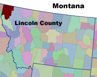 Setting: Lincoln County, located in northwestern Montana, borders British Columbia, Canada to the north and the Idaho to the west. Libby, the county seat, has
population of less than 3,000, 12,000 people live within a ten-mile radius, and a total of 18,827 residents live in this rural county with a density of about 5.3 people per square mile (compared to the
national average of 80 people per square mile). Lincoln County has a wide diversity of forest-based natural resources, including productive forests, many fish and wildlife species, and outdoor recreational
opportunities. In 1997 twenty-seven percent of its workers were employed in wood products manufacturing. Since then, Lincoln County has experienced a high level of unemployment concurrent with the closure
of several lumber mills. In 2001 Libby was designated as a Superfund site due to contamination from asbestos mining.
Setting: Lincoln County, located in northwestern Montana, borders British Columbia, Canada to the north and the Idaho to the west. Libby, the county seat, has
population of less than 3,000, 12,000 people live within a ten-mile radius, and a total of 18,827 residents live in this rural county with a density of about 5.3 people per square mile (compared to the
national average of 80 people per square mile). Lincoln County has a wide diversity of forest-based natural resources, including productive forests, many fish and wildlife species, and outdoor recreational
opportunities. In 1997 twenty-seven percent of its workers were employed in wood products manufacturing. Since then, Lincoln County has experienced a high level of unemployment concurrent with the closure
of several lumber mills. In 2001 Libby was designated as a Superfund site due to contamination from asbestos mining.
Land Ownership: Almost ninety-three percent of the county is classified as forest land –seventy-seven percent of this is managed by the USDA Forest Service as the Kootenai National Forest. Industry-owned
forest lands are significant in the county–currently Plum Creek Timber Company owns 270,000 acres and Stimson Lumber Company owns 30,000 acres. Increasingly, post-harvest timberland is turned to
residential subdivisions, given its higher value as real estate. Non-industrial private forest lands comprise a very small portion of the county. The State of Montana’s Department of Natural Resources
and Conservation manages about 165,000 forested acres of Montana School Trust Lands in the county.
Two social trends exacerbate the risk to a growing population within the WUI. First, mill and mine closure economic impact has created a large percent of low income families who cannot afford to create
defensible space around their homes. Second, recent population growth from out of state, particularly by people seeking homes in a forested environment, includes people unfamiliar with fire behavior
and the potential for destruction of their property.
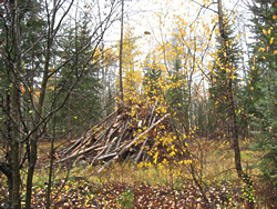
 Vegetation Type: The majority of the WUI areas in the county have very similar vegetative configurations. Most of the large trees have been removed through logging over the past 70 years. The remaining
trees tend to be younger and smaller, but more importantly they are often species such as Douglas fir that are more tolerant of
Vegetation Type: The majority of the WUI areas in the county have very similar vegetative configurations. Most of the large trees have been removed through logging over the past 70 years. The remaining
trees tend to be younger and smaller, but more importantly they are often species such as Douglas fir that are more tolerant of
shade. Low intensity surface fires historically kept ground vegetation from becoming ladder fuels, but fire suppression has changed this; in addition to more ladder fuels, ground fuels (e.g. litter mat,
down woody materials) contribute to the risk of high intensity fires.
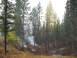
Fire History and Occurrence: Lincoln County has witnessed many large, uncharacteristic wildfires. Sixty thousand acres burned during the 1994 fire season. In 2000,
the area experienced another record fire season with 270 fires burning a total of 45,465 acres. That year the Kootenai National Forest managed four large fire complexes, requiring eight incident management
teams. Fire fighting resources were stretched so thin that military resources were ordered along with an incident management team from Australia. The 2000 fire season did not result in the loss of lives
or homes, but the potential was definitely present. Although residents were well aware of the potential hazard from fires, few residents have taken steps to reduce hazardous fuels around their homes.
 CWPP Process: The Lincoln County Commissioners hired a consultant to develop the CWPP with input from a CWPP committee, the Lincoln County Fire Steering Committee. The CWPP prioritized fuel reduction
treatments in subdivisions with willing homeowners and promoted the Firewise Communities USA concept in order to motivate communities to be more self reliant. Interviews with fire department staff helped
identify problems, capacities, and measures needed to reduce insurance ratings in their districts. Priorities for fuel reduction projects were identified on private lands; recently the Lincoln County
Fire Steering Committee has recommended that the WUI be extended onto federal lands where the private and federal lands abut. Two other collaborative groups, the Kootenai Stakeholders Group and the Lincoln
County Forest Stewardship Coalition, have formed to address the need for hazardous fuel reduction on public land, to identify opportunities for stewardship contracting, and to develop small diameter
milling capacity.
CWPP Process: The Lincoln County Commissioners hired a consultant to develop the CWPP with input from a CWPP committee, the Lincoln County Fire Steering Committee. The CWPP prioritized fuel reduction
treatments in subdivisions with willing homeowners and promoted the Firewise Communities USA concept in order to motivate communities to be more self reliant. Interviews with fire department staff helped
identify problems, capacities, and measures needed to reduce insurance ratings in their districts. Priorities for fuel reduction projects were identified on private lands; recently the Lincoln County
Fire Steering Committee has recommended that the WUI be extended onto federal lands where the private and federal lands abut. Two other collaborative groups, the Kootenai Stakeholders Group and the Lincoln
County Forest Stewardship Coalition, have formed to address the need for hazardous fuel reduction on public land, to identify opportunities for stewardship contracting, and to develop small diameter
milling capacity.
Participants: The Steering Committee is led by Ed Levert, retired USFS District Ranger and contracted by the County as National Fire Plan Coordinator and forester. He is assisted in community and homeowner
outreach efforts by Montana Department of Natural Resources and Conservation forester Keith Kenelty. The Northwest Regional Resource Conservation and Development Council administers grants for fuel reduction
and provides foresters to work with homeowners. Volunteer Fire Departments conduct firewise home assessments. Other entities represented on the Steering Committee include the Kootenai National Forest,
Lincoln County Planning, Fire and Emergency Services Departments and Plum Creek Timber Company. Insurance companies, realtors and the Flathead Electric have participated at times.
Status: The Lincoln County Community Wildfire Protection Plan (CWPP) was first written and approved in 2003 and is incorporated in the county’s 2004 Pre-Disaster Mitigation (PDM) Plan. Since that
time many of the goals have been accomplished, some goals have been abandoned and new goals have been added. The 2003 CWPP enabled Lincoln County to better compete for National Fire Plan money available
through the Western States and the Stevens Act Wildland Urban Interface Grant programs. The county was able to fund all of the identified projects for private land in the 2003 CWPP; new funding is currently
available for property owners.